from the polder layout department
The Netherlands are often held up as a model for good practice in cycle policy. I've made the point already that the country has a number of geographical peculiarities which mean that its methods should be interpreted with caution when considering generalizing them elsewhere. Of course it is possible, indeed more enjoyable, to ride a bicycle in more hilly terrain than any the Netherlands has to offer. But the techniques required by both the cyclist, and the urbanist seeking to encourage them, are self-evidently going to be different. This much is obvious.But there are a couple of more subtle points to l'exception néerlandaise that have occurred to me since my pilgrimage to Groningen last year:
 |
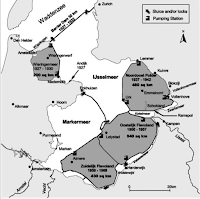
| 20th century polders, from Hoeksema (2007) |
2) In a country where for centuries the canals have been the main axis of transport between towns, it may be that it seems quite natural to have a "major" and "minor" towpath. I noticed on my trip last May that very often I received strong cues from the urbanists to travel on one side of a canal-line (which was often a mixed-use low-speed residential street), while across the water I could see cars moving quite fast on a higher speed street. I was cool with that as long as getting to the "right" side didn't take me too far out of my way. As a tourist, naturally I just went along with it, but I could imagine being a local resident with a bike and being daily pissed off by the tortuousness of the route I was obliged to follow. (Obligatory) cycle routes along major trunk roads often jink from one side of the motorway to other, adding significant travel distance perpendicular to the desired direction. This sucks.
We should be clear about all these distinctions when considering the applicability of Dutch cycle infrastructure design to other parts of Europe, where the width of roads and streets (their frontage-to-frontage distance) was determined in the era of horse-drawn vehicles. Horses go home at night, and the carts they were pulling too. So three cart-widths would be pretty much enough anywhere: one delivering, two passing in either direction. On-street parking is a twentieth century curse. Where such conditions exist historically in the Netherlands, they tend to mostly exclude motor traffic (as of course you should). Parallel universes of "protected cycleways" may be an option in new towns and suburbs, but in the vast majority of European cities the nettle of private car dependence must be grasped.


Aucun commentaire:
Enregistrer un commentaire